World Dream Bank
home -
add a dream -
newest -
art gallery -
sampler -
dreams by
title,
subject,
author,
date,
places,
names
Capsica's homepage, map, giant ref map, geography,
gazetteer
. More worlds? Planetocopia!

 Capsica: Lindara Plateau
Under construction! Stub only!
by Chris Wayan, 2024
Dedicated to Death for prodding me to finish
Capsica. This is the last tour. Only took 14 years!
Introduction: the Last Region
-
Touring -
Northeast -
East -
South -
Sky Islands -
Northwest
Well! "What a long strange trip it's been." I've been trying to finish the skeletal regional tours of Capsica, always promising I'd finish next year... for 14 years. Talk about self-delusion. I just didn't want to face the true size and complexity of an entire world. It's a personality flaw--the relentless drive to work things out realistically, in Earthlike detail. Now I know why Tolkien, trying to finish the Lord of the Rings, dreamt he was painting a monstrous, endless mural he'd die before finishing (he wrote his dream up as one of his odd(er) stories, Leaf by Niggle). I just couldn't let it alone.
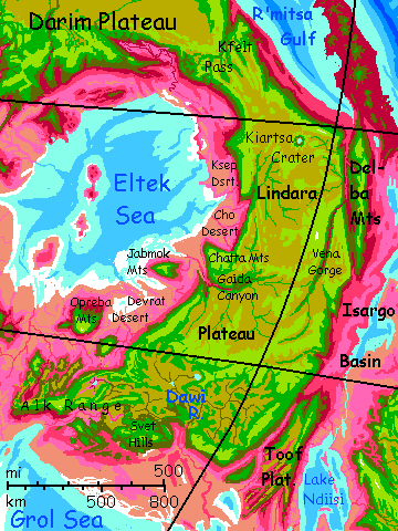
So here we are--the last of fifty regional tours. It's not chance that all the final tours--Droom, Grol, Tralken, Darim, and Lindara--have been in the inland Crunch, that rather Central Asian region where old tectonic plates go to die, and tourists, old or not, do too. Hard to write routes that let readers live. Not that any Capsican tours are easy, but just as Tolkien dreaded writing the the Mordor chapters, I dreaded these last few. For these hot, rugged, salty, alkaline, blighted basins resemble Mordor more than I'd like.
Every world has armpits. Capsica's is really big.
Intro -
Touring
-
Northeast -
East -
South -
Sky Islands -
Northwest
I'm assuming that anyone venturing here, in the dry and dangerous inland Crunch, has some experience flying on Capsica on rented wings. Your shoulders have stopped hurting, you can spot likely updrafts, you're used to low gravity and high air pressure, and of course, as always, extreme heat, making the lowlands fatal.
Okay, I've stated the obvious. You've been warned.
Except for its northeast edge, Lindara Plateau's in the dry inland Crunch, and at low latitudes--hence, hot even for Capsica. Terrans can only tour it (somewhat) safely in winter, sticking to the heights.
We'll start in late fall at Kfelt Pass in southeast Darim Upland in the Crunch's tropics, and circle Lindara's rim more or less clockwise, with side trips. That'll keep us on the milder, wet(ter) side for some weeks, letting you adjust, before tackling the stark inland rims, where heat and water become hazardous. I mean, more hazardous. Seasons change fast on Capsica--barely nine weeks each--but if we hurry it should be early spring and still quite cool as we swing back to the equator. Sweaty, but not fatal.
Anyway, just wanted to warn you I may move you along pretty fast. It's not that Lindara isn't scenic--it is.
But it's just bad form for a guide to let tourists die.
Intro -
Touring -
Northeast
-
East -
South -
Sky Islands -
Northwest
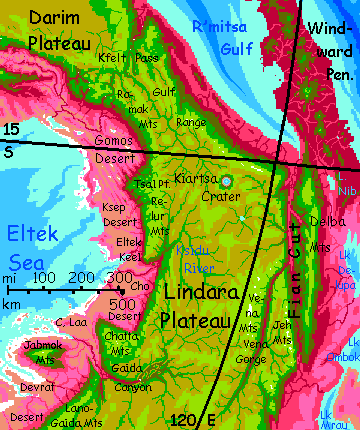
So you're riding the updrafts along the R'mitsa Front, where the winds off R'mitsa Gulf hit that mountain wall and rise five miles. You're at a low latitude on a sweltering world, yet the highest peaks above you gleam with streaks of snow, for several top 8.3 km (27,000'). And the R'mitsa Front's not unique on Capsica; vigorous tectonics plus low gravity makes it easier to build Himalayan ranges. Though they're big angular castles; they lack that jagged Ice Age look of Earth's highest ranges; snow falls, but melts in summer; only when it heaps up into over years into glaciers can ice carve peaks into horns and cirques. The crags are carved by thunderstorms, not ice.
Southeast. The first day's a straight, easy ride--provided you stay two or three miles up, waist-high on these giants. Luckily that's easy--the winds off the sea rise, lifting you without effort. Cool streams, some snowmelt, cascade down every few miles; if you overheat you can stop and swim. Green meadows, scattered, open woods. Earthlike! Lower, the reds of heat-tolerant rhodofers start to spangle the vegetation, and at the mountains' feet, deep ruby-red forests, purpling in cloud-shadows--and puffy white clouds like a dense herd of sheep graze this coast, unlike any other on this trip. R'mitsa Gulf is an arm of the world-sea, and rain is plentiful. Like Paradise seen through infrared eyes. Though not for you; it's the cool dry season, but still 45°C down there (113°F) with 80% humidity. Stick to the green heights.
Today, through cloud-gaps, you can see R'mitsa Gulf sparkling to the northeast; the dropoff's quite steep here, the coastal plain narrow. It soon won't be.
Day two: south along the coast. Waterfalls, clouds, mist, rainbows. Now just more hills on the eastern horizon--spurs of Lindara Plateau.
Day three: above you, the mountains march on, but the summits are only (only!) 6-7 km up (20-23,000'), and snowfree. Just not high enough for more than flurries, even now in early winter.
Day four: a side trip inland. Spiral up as high as you can, and over a low pass, just 5 km high (16,400'). West across the Plateau--dry grassland, but unlike most on Capsica: not lilac or pink, the colors of dried heat-tolerant rhodofer grasses, but tawny Earthlike golds. It could be African savanna. Flight here is hard--the air's rich in oxygen and even at this height, 4.5 km (14,800') it's denser than Earth's, but you never evolved to fly--you need both boosts, low gravity and dense air, preferably with a third, updrafts. But up here, you really have to work to stay aloft. Skim low--the grass beneath your wings will trap the air you compress with each beat, giving you a boost: the Ground Effect. But stay alert for crags and stray rocks. And there sure are a lot of those for a world without glaciers to transport them. How'd all these strays get here?
The answer lies ahead, over that low ridge. Puffing, you land... on the rim of a great dropoff to a valley round as a bowl, cupping a lake at the center. Kiartsa Crater, 95 km across (60 mi). Not a caldera--one of the few visible impact craters on Capsica. Twenty milllion years ago a rock perhaps 5 km across hit Lindara Plateau. Because the region's fairly dry it hasn't eroded much; and the grass and high altitude keep down the dust common in the lowland Crunch, so it hasn't filled in much either. Not yet at least. Maybe in twenty million more...
The crater's not that much smaller than Chicxulub on Earth--the dinosaur-killer. But the impact did less ecological damage. There were no nearby forests to burn,.the rim-ranges blocked some of the shockwaves from flattening more distant forests, and tsunamis were modest. Further, the plateau's rock isn't carbonate like Earth's limestone reefs, so the explosion didn't dump carbon dioxide into the air. On Earth, impact survivors faced twin climatic punches--first they froze in the dark for a year (or ten), then faced heatwaves and crazy weather for generations. Capsica had summerless years and shocking cold, down to 20°C (68°F) but as the smoke cleared... that was all. Barely a planetary owie.
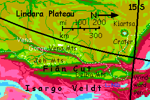
Day five: follow that east-running stream back out to the rim of Lindara. New the lip, the high, dry, golden steppe greens, and trees spread beyond streambanks. Groves and true woods. At the dropoff, red below.
But the gleam of sea out east is gone: instead of a coast, it's a canyon 4-5 km deep (13-16,000'), one of Capsica's deepest (and that's saying a lot), running south beyond the horizon, arrow-straight. It's not a watercarved canyon but a monstrous fossa, a crack due to corrugation and subduction; this is a platelet boundary where the R'mitsa Gulf basin runs up on land, narrowed to just 40 km (25 mi): it's called Fián Cut. The sun's behind you; go ahead and cross. You may sink some over the red-forested floodplain of the Fián River, but the afternoon sun shining full on the east wall--the Delba Mountains--heats that face; updrafts will lift you back to the safe, cool, green heights.
Day six: east across the Delba Range--broken highlands with odd sandcastle-peaks, like Ethiopia. The eastern slope drops more gently than the great gash of Fián Cut, but water gleams--a last arm of the sea? No. Lake Nib. Freshwater, running south toward the monstrous lake-complexes of Isargo Basin in the Southeast Crunch. Overhead, Capsicans fly south, like gigantic geese (well, more like pelicans, pterodactyls and griffins). But for a good 500 kilometers to the southeast, Isargo Veldt is low and fatally hot; not a flyway Terrans can safely follow.
But you do have the way to skip the inland barrens. Go fly amid rainbows on the lush tropical mountains of R'mitsa! Head north along the Delba Range; after a day or two it slumps and dies, smothered in red lowland rainforest, but beyond, great volcanoes rise; their shoulders are green-wooded, safe for Terrans. It's the exact equivalent of a Terran island arc, just one with sky-islands rising from a sea of fatal jungle. You'll be island-hopping all the way, but the chain never gives out; you can reach the gorgeous equatorial highlands of Lrota-Keh.
Intro -
Touring -
Northeast -
East
-
South -
Sky Islands -
Northwest
South along the Delba Mountains.
Recross Fián Cut to the west side. South... Waterfalls worthy of Roraima every few miles. Fewer clouds though, and forests, both green and red, more open; the Delbas block half the rain off the sea.

The mouth of a side canyon fully as deep as the Cut, but just five km wide--Vena Gorge. Sheer cliffs, bare rock in places. It widens upstream in places to 15-25 km (10-15 mi) but never more--and it's two to three times as deep as the Grand Canyon.
Up the Vena River... waterfalls.
The Vena Mountains--the highest in Lindara Upland: 9 km high (almost 30,000'), so high that several peaks bear glaciers. Actual ice-carved horns along the high divide. The range is a straight north-south line about 450 km long (280 mi), though lesser hills (as in 5 km high) curve west from its south end to cross the plateau. This "low" wall is the informal divide between North and South Lindara.
A day past the climax of the Vena Range, it's time to leave the Gorge and head back out toward the (south)east rim of Lindara Plateau; we needed to get round the Jeh Mountains, a second Himalayan range with peaks 7-8 km high. Snow streaks on their shady south faces.
Back on the rim, we're well inland now; coast no more. It's grassland down there in the Isargo Basin, not rainforest; plenty of heat but too little rain. Mostly it's old dry grass, pale pink--summers are dry but for unreliable thunderstorms, and this was a scant year.
Next day south, you cross the mouth of Tsii Gorge--40 km wide, 3.7 deep (25 mi, 12,000'). Dusty-rose scrub in the depths, and down the middle, a series of white rapids blasting clouds of mist. A mile-wide strip of deep red forest, mist-fed. Scenic, but I don't recommend landing even for a brief visit. For Capsicans it's a weird little strip of damp, bone-chilling cold; but that's still 35-40°C (95-104°F)--and 100% humidity. On to the south rim, two miles higher and nearly ten degrees colder.
Next day south, clouds sweep in from ahead--the pole, not the tropics--and drop a little rain. That settles it: no longer late fall, but early winter. You can go as low as 3 km (10,000') without too much heat stress now...
Late the next day, you're 300 km south; below your left wing is savanna that little storm rained on well before it reached you; two days ago, not one. Already, bright lavender new grass is rising from the dusty pink.
Next day, a floating sky-island humps up on the eastern horizon, turning the wide veldt beneath you to a cliffwalled valley just 40-50 km wide (25-30 mi). That far wall is the rim of Toof Plateau, another splinter of an ancient plate, like the Delba Mts far behind you; hundreds of km long, several km high, but wider than Delba--at least twice its area. The gulf between isn't a water-carved gorge but a fault-valley, Rah Fossa, nearly as straight and savage as Fián Cut was. And drier, with bare cliffs. The valley floor's dead, dry, pinkish grass with bare tan sandy patches; an old worn rug. We're farther from the sea.
Out across Rah Fossa onto Toof Keel, the narrow north end of the plateau.
Beyond its ridge, three miles high, dark basaltic cliffs drop to living, lavender grass far below. Stripes down the cliff, green at the head, shading to red at the foot, mark seasonal waterfalls. Tiny creeks, not rivers. This isn't Yosemite. The upland's too narrow to collect much runoff.
The lusher grassland on this side of the Keel isn't fed by these modest creeks, nor by rain off the sea--that's many days' flight to the east, over high mountains. You'll see what feeds that grass tomorrow...
South along Toof Front. Ahead, the lowland turns coastal--not the sea, no coral in those shallows--instead, vast reedy flats with sinuous silver sloughs. Lake Ndiisi, the largest freshwater in the hemisphere--an island-dotted chevron shape 900 km long and up to 400 wide (560 by 250 mi), with a surface area equal to all our Great Lakes combined; the Lower Isargo River drains it north into Lake Mrau. That drainage is critical; if Ndiisi were cut off, like so many basins in the Crunch, salt would build up, and its level would vary more, both seasonally and in longer cycles; it'd turn into a small sea, still generating rain, but also generating salty, desiccating dust from its treeless, brine-poisoned shores. As it it, this cluster of eight great lakes, with a surface area of 7-800,000 square kilometers (about 300,000 sq mi; bigger than our Black Sea) makes the Isargo Basin mild for the inland Crunch; few trees, but rich grasslands.
A day south along this narrow, dramatic coastal strip, you spot the mountainous far shore of the lake, hazy, faint--a good hundred miles out. You're two miles up; it's possible, despite little Capsica's sharp curvature. But it's not the far shore: that's Kadelim, the largest freshwater island in the world, an arrowhead shape nearly 100 km long and 50 wide (60 by 30 mi).
A straggle of Capsicans like monster geese plunge off Toof in a crude V, heading east toward Latta Upland on the far side of Lake Ndiisi. This is the narrowest point of the Isargo Basin. Don't follow; narrowest is not narrow. Still 400 km of deepwater and hot savanna, both fatal to land on. Even the hills of Kadelim are too low and hot to camp safely on. Stick to the heights. A monotonous rule on Capsica, I know. But the only one keeping you alive.
Next day the coastal strip below you narrows. Wooded mountains dropping to savanna on the "sea". Red snakes of lowland woods mark watercourses. Every creekmouth has a village--you spot gardens and fishing boats. Rural Edens, if you could take the winter heat.
You can't: it's 45°C down there, soon to rise to 50-55 (113 to 122-131°F). Stick to the cool heights where it's just 30 (86°F).
We're far inland, some 35° from the equator now, in deep winter; on Earth, such places (like Central Asia's steppes) can drop to freezing. Why is the lowland here still unbearable? Blame the lake. Water holds heat; it's a huge thermal anchor. If the basin were desert with just small streams, it'd likely be visitable, at least briefly in winter--now. But Lake Ndiisi cools the summers, warms the winters. An almost maritime climate--paradise for natives year-round, fatal to you.
Still, the rain Ndiisi generates keeps it nice up here--green grass, green trees. If not many--just along the little creeks--more wadable than swimmable. And don't get swept off as these warm little trickles leap off the scarp and down to the lake--well, halfway. Most fray to white banners of mist before they reach the red zone.
Enjoy the trees while they last. Ahead is the real Crunch.

Two days south to the end of Toof Plateau. Stick to the eastern, "outer" rim; to the west are rugged dry-brush gorges around a mile up--less impressive, and uncomfortably hot. It's not really a plateau--more a comb with twisted teeth, with the east ridge above Ndiisi the only continuous height.
A line of Capsicans are flying south along this spur, toward huge G'lasa Upland--almost Terran, with green forests, real rivers (it's the source of the Isargo, the biggest feeder of Lake Ndiisi), even snowcapped peaks. But it's a difficult flight for Terrans on rented wings--the spur sags in the middle for hundreds of km; few updrafts and nowhere safe to rest.
West across rough ridges and brushy canyons. A full day of confusion. No easy soaring here! Updrafts and downdrafts. Stay alert.
Lenot Mesa, a high green leaf-shaped plateau some 4.7 km up--15,200'--high enough to harvest more rain. Earthlike meadows and even sparse forest.
On to the west. Recrossing Rah Fossa, one of your party suffers a wing failure--a monofilament tendon snapped. You're forced down toward the forbidding desert floor. Aim for the creek--can't call it a river--collecting the meager streams off the cliffs. You can survive this! The very factor that make Rah Fossa an oven in summer--its aridity--lets it cool more now in winter than the lush shores of Ndiisi. It's about 38°C (100°F)--but it's dry heat.
So you land on a sandbank, find a boulder offering shade, and splash in the water to cool off. Thread your replacement tendon in--slow, hot, fussy, crowded work; it's not easy to make wings light and responsive enough for Terrans on Capsica!--but you won't die, even trapped in the lowlands for hours. And once it's mended, you can ride updrafts to the cliff-heads looming northwest: the foothills of the Boleh Range, Lindara Plateau's southern tip. Rising 6 km (nearly 20,000') the Bolehs are high enough for water, shade, and a cool campsite--dropping briefly to the high 20s in the night (down to the low 80s Fahrenheit).
Continental winter!
Intro -
Touring -
Northeast -
East -
South
-
Sky Islands -
Northwest

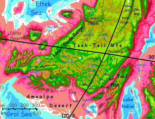
West from the southern tip of Lindara Plateau, along the Boleh Front. Below is the dusty desert basin of the Grol Sea. Wide alkaline salt flats around the sea make that dust mildly caustic; the land's orange, brick, black, dun or gold, depending on the rock; little red, lavender or even dry pink. Not friendly land, even for locals. Villages do line the banks of the Dawi River, a winding snake collecting runoff from much of South Lindara; it's still shallow, a Nile not a Congo.
Across the floodplain of the Dawi, all morning. Villages dot the river, with gardens visible from miles above. It's the only stretch of the river that's densely settled, above the gorge, Capsicans find the basin unpleasantly cold, dry, lonely, and barren; and the lower Dawi suffers salty, caustic sandstorms off nearby Long Pan and the Amsalpa Desert. Typical of the whole Grol Basin, really. Most Capsican seas have delta ports; not the Grol. Some fish have adapted to its dense brine, but Grol is just hell to fish, or even sail on, or even live near. Metal corrodes, wood pits and cracks, fun evaporates. Ah, but we here at Capsica Tours Incorporated are relentlessly thorough... so suffer on, you masochists!
West from Dawi Gorge... into the many peaks of the odd Svet Hills, up to 4.4 km high (14,500'), a confused mass of sparsely wooded peaks, living off sparse winter rains and random summer thunderstorms. Dry canyons with few streams exiting--most dead-end in sinks or saline sumps. Hop from peak to peak and stay out of the low-altitude maze! The Svet complex is probably the shrunken corpse of a whole platelet, crushed in so many directions its structure no longer makes sense. But they're the highest, coolest and best-watered terrain in this delightful stretch of the Crunch.
A day and a half, generally west, but even crows can't fly straight in the Svet Hills. At last, an alternative--a distinct ridge heading north, a barrier to the prevailing winds. Consistent updrafts! Follow that highway.
Within a day, you reach a real mountain rainge, the East Alks, 5-6 km high (16-20,000'), running west--just what we want. Sun to the north, your shadow's cast south, down the long slopes of the Choga Valley. Sheltered from dust by the Svet Hills, Choga's actually livable. For Capsicans of course. Not you.
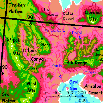
Ahead: the snowy peak of Mt Alk, 8 km high (over 26,000'). Real forests, real streams! A Terran patch in the desert of the Crunch.
On along the West Alks, again 5-6 km high (16-20,000'). Given there's desert all around, there sure are a lot of Capsicans around you today. Just passing through! The West Alks are a bottleneck on a significant flyway crossing the Crunch sea to sea--essentially Capsica's Silk Road. Not a pleasant link in that long chain, but a vital one.
Where the Alks slump into desert, we turn north at last. An hour or two north is the jumping-off point to Tralken Plateau in the very heart of the Crunch. It's a hazardous flight for Terrrans--200 km (125 mi) over a Capsican desert intimidating even to locals. But plenty of Capsicans take it; at least it's (by their standards) short. Other crossings are worse.
To your left: those dusty-rose creekbeds are the headwaters of the shallow Kamin River, winding south to the Grol Sea. The ruddy snakes to the right are fingers of the Dafai River, running north, to the Eltek. This little promontory's the divide.
Strange parallel ranges north of the Alk Mountains, like fingers, or the teeth of a comb. Curiously like the ridges of R'lpok Canyon to the west, on Tralken Plateau, though that's a separate plate; they can't be sundered parts of one structure. They have to be products of similar forces (brutal compression, mostly); a geologic echo of biology's parallel evolution. Head northeast across these ridges--not as high or cool as Lindara Plateau proper, but now, in deep winter, and as far from the equator as we'll get on this trip, the heat's bearagble. Dry, though; sparse woods to brush to bare rock, and desert canyons below, rainshadowed in every direction. Only scenic if you're moved by hard life or none at all.
But I promise it will get better. A bit.
Intro -
Touring -
Northeast -
East -
South -
Sky Islands
-
Northwest

Northeast. Far off--usually invisible in the heat-shimmer over the Dafai Desert--you think you see impossibly high peaks, so pale in the haze you can't be sure.
Across a 25-km gap to Lindara proper, and a higher, sustained range, the Lano Mountains. Real creeks, not just trickles and waterholes. They're high enough--over 6 km, 20,000'--to wring real if infrequent rains out of the stingy winds of the central Crunch.
Take the next jump-off on faith. Head north off Lindara, over the lowland Devrat Desert toward that mirage. It's real--a sky-island, the Dan Mountains, 6.7 km high (22,000'). It's a single tilted block over a hundred miles wide, and I won't describe it in detail because it's just a way-station. I'll save the superlatives for the next island, our real goal...
...the Opreba Mountains, a wedge twice as wide as the Dans and nearly twice as high--over 11 km (nearly 33,000'). More to the point, Opreba's highest peak, Mount Liih, is right at the edge, rising from the low desert in one monstrous scarp, from dun through pink savanna to scattered olive trees to green forests to chartreuse meadows lush now in the winter rains, and still rising, to lichen-lurid stone, impossibly rising, to ice-fluted crags and towers--all in a few miles. Opreba is one huge rock slab--a surviving shard of an ancient continent--that the Crunch's age-long squeeze has tilted like an errant square of pavement heaved up by frost or a relentless tree-root.
Tilted blocks like this aren't unique to Capsica. Mt. Pillan on Io is comparable; so is the tilted granite slab of the Sierra Nevada, though it's lower, in Earth's higher gravity.
Opreba is lucky; it tilts toward the sea, not away. The whole long north slope catches rain. A true ecological island of fertility in the mostly grim Eltek Basin. One geologic neighbor, the Jabmok Range, is nearly as high, but is less rich, for it tilts away toward the Lindara Plateau.
More typical of this coast: just to the east, a blinding white flat: Devrat Pan. A salt plain nearly 200 km long.
Back to the Dan Mts. This time let's head due east, back to the Lindaran "mainland"--it's a second 'strait' no wider than the southern one we entered on.
Intro -
Touring -
Northeast -
Southeast
South -
Sky Islands -
Northwest

Now we ride the winds up the Lano-Gaida Range--one of the longest in Lindara, nearly 1000 km (over 600 mi). Not as high as Opreba's impossible peak, but Andean--many 7-km peaks (23,000'), enough for some snow now in late winter. The wind's off the sea, rising as it strikes the mountain wall--effortless sailing, mild temperatures for Capsica, rarely over 30 (86°F) and nearly as much greenery (and swimmable creeks) as on Opreba. Even the lowland below has mellowed from desert to savanna--and not dry grass, but that implausible lilac of Capsican spring.
Two easy days up this flyway to the mouth of Gaida Canyon; the river-strip a wide braid of greenish shallow channels and red forest, strange after days of grassland. Here we could fly out over the lowlands, downriver then west a bit to a third great tilted block: the Jabmok Range. But you've seen two, and Jabmok's drier, for it tilts away from the sea. The heights snag just as much rain as Opreba, but most runs down the coastal scarp.
Let's go inland up Gaida Canyon instead. The cliffs are just as spectacular, and (facing the sea and incoming storms) they get a bit more rain.
Inland a day. Gaida Falls; the river draining all central Lindara drops 700 meters (2300'). Not quite Angel Falls, but no mere creek; a torrent.
Upstream, a strange braided canyon some 2.4 km deep (8000'). Like Grand Canyon, it's full of mesas and castles. Its origin is quite different, though; it's not that this land slowly rose; Lindara's been a highland a very long time. But its edge was here, once; the Gaida River wound across lowlands here toward some broader ancestor of the Eltek Sea. As the Crunch squeezed plateaus and lesser sky-islands together, some fused with Lindara Plateau; the north wall of Gaida Canyon is one. The Chatta Mountains, an even more recent accretion, still stand out as distinct.
In the Crunch, platelets accrete the way big galaxies swallow little ones.
Northwest to the Chattas, craggy peaks 7 km high, shaped like a drunk toddler tried to make a sandcastle. Not ice-sculpted, or even water-sculpted, for the most part; geological pressures upthrust squeezed and tilted them as they slowly collided with the main mass of Lindara. Chatta was once a sky-island like Opreba or Dan, and it hasn't surrendered meekly to digestion.
North along Lindara's rim above the Cho Desert. Essentially rainless; what plants there are survive on groundwater charged by the Cho River in the south and the Ksidu in the north.
The mouth of Ksidu Gorge. Quite as deep as Gaida, but far simpler: a deep single gash with sheer cliffs up to 3.7 km high (12,000').
Let's head a couple of hours west, out to Eltek Keel, one of the few places on our tour where it's possible on a good day to see the Eltek Sea--another was in the Chattas, but we'd have had to backtrack a full day. Hardly worth that--just a silver glare on the western horizon, a bit lost in the equally glaring salt flats down there...
North two days along the slope of the Relur Mountains, a massive range, snowless of course--we're in late winter now, and returning to the tropics, and they're little over 6 km tall (20,000').
Tsal Point, a promontory matching Eltek Keel. The lowlands to the north look different--still dry, but rumpled and complex, with sparse trees on higher ridges. Unfortunately most of those valleys wind nowhere; streams dead-end in brackish lakes and sinks.
Two days north-curving-west along the Ramak Range, forming a great crescent or bight cupping this convoluted land, the Gomos Desert. Pinkish ridges, dun slopes, whitish salt flats.
The plateau is growing greener, though--under 15° south now! This is monsoon country, getting significant (if variable) summer rains. Trees quit clinging to streambanks and creep up the slopes. The peaks and shoulders of the Ramaks are quite snowless of course; just 5.5 km up (18,000') in the tropics, the late winter chill is just room-temperature.
Even the northern Gomos responds. Streams here have carved channels to the sea. No more salt pans! Dry grass and scattered, wizened trees. Not pretty, but an improvement.
Follow a deep gorge heading inland--north now, not east; Lindara's curved that much. Rugged peaks, shockingly green after weeks of the inland Crunch; the valley floor olive--a few red trees still in the mix. Impossibly, just as the last reds fade out, around 4 km up (13,100'), the valley reaches a divide; you've crept just 160 km (100 mi) into the upland yet streams now run east! Red trees return within the hour. A waterfall, and below the plume of spray, reds predominate beneath you. The gorge opens, and below you, far ahead, you see a plain of clouds.
A cloud-gap opens. Deep blue. Not the purple of shadowed red rainforest; the sea! You crossed the upland in a day.
Look familiar? Kfelt Pass and R'mitsa Gulf, where you began--fourteen years ago I mean, weeks ago.
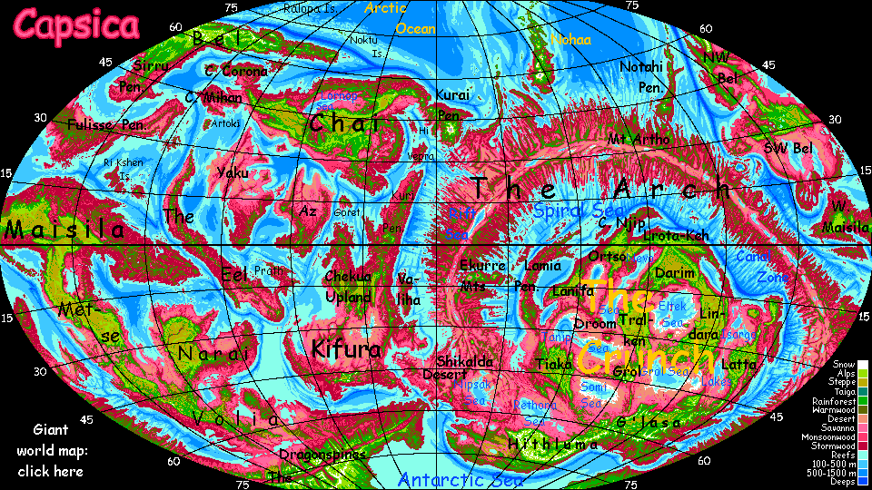
LISTS AND LINKS: more world-models:
Planetocopia - dreams of
other worlds -
ecology -
climate -
hot & cold-
evolution -
anarchy &
utopias -
sculptures & 3D art
World Dream Bank homepage - Art gallery - New stuff - Introductory sampler, best dreams, best art - On dreamwork - Books
Indexes: Subject - Author - Date - Names - Places - Art media/styles
Titles: A - B - C - D - E - F - G - H - IJ - KL - M - NO - PQ - R - Sa-Sk - Sl-Sz - T - UV - WXYZ
Email: wdreamb@yahoo.com - Catalog of art, books, CDs - Behind the Curtain: FAQs, bio, site map - Kindred sites
Capsica: Lindara Plateau